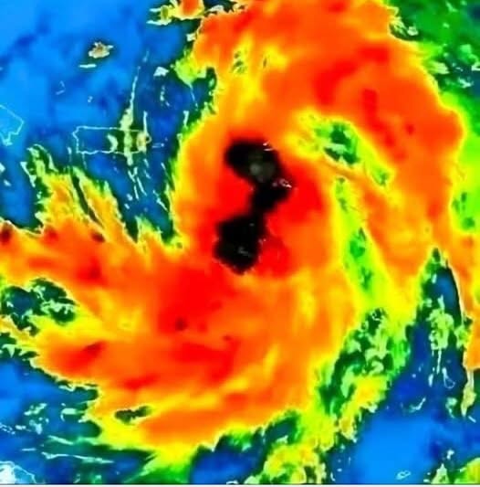
The image looks alarming for a reason. When colors intensify into deep reds, oranges, and blacks on satellite imagery, it signals rapid organization and strengthening inside a storm system.
But here’s the important part: images like this spread fast online before full details are confirmed, which often causes unnecessary panic.
So let’s break down what’s actually happening.
This type of satellite image shows:
- Extremely cold cloud tops (a sign of strong upward motion)
- Heavy rainfall bands forming around a central core
- Increasing wind intensity within the system
In simple terms, the storm is gaining strength, not disappearing.
However, at this stage:
- Exact landfall is not confirmed
- Final intensity can still change
- Some storms weaken just as quickly as they strengthen
Meteorologists monitor these systems constantly using satellite data, ocean temperatures, wind shear, and pressure readings. A storm that looks dangerous on an image still needs official classification before any real conclusions are made.
What people should do right now:
- Stay updated through official weather services
- Avoid spreading unverified claims or fake landfall maps
- Prepare calmly if you live in a storm-prone region (water, batteries, plans)
What people should not do:
- Panic based on a single image
- Assume worst-case scenarios
- Trust posts that use “BREAKING” without real details
Storms are serious—but misinformation spreads even faster than weather.
Awareness is preparation. Panic is not.
If this system becomes a true threat, authorities will issue clear, direct warnings through official channels.
Until then, stay informed, not frightened.